Thursday, October 15, 2009

A sunny place for shady people.


It was a challenge, but we've finally found a place to call home, and I'm proud to say that our home comes complete with no wicker. For about two months we've been our own version of Island House Hunters. I managed to con Matt into giving up precious fishing hours to cruise around the island with various landlords, real estate agents and a professional looking tablet in which I scrawled indecipherable facts and figures, complimenting the homes while secretly thinking “those yellowed lace curtains look like they were striped off a corpse” “I would be scared to sleep in that bed” “eww... there's a cockroach crawling around in here” or “I wouldn't be able to live with myself if we chose a spot that housed salmon and teal colored walls with 3 versions of pastel flower motif in the same room.” We had seen so many places that our real estate detective skills began to falter and we ended up looking at a couple of the same houses twice... by accident.


The up side of all of the housing stress was that we were able to check out every nook and cranny of the island. Real estate agents would drive us around for hours, showing us places, along the way, sharing their knowledge of the island's “little secrets”. We were taken to hard to reach beaches, and handed connection after connection. One thing we've learned from our trials is that everyone is connected. Tortola is a small world, or maybe just a very small island. Every one is connected in some way shape or form and everyone is very willing to lend a helping hand. For instance, a random man who scolded us for lifting the hood of his car that said FOR SALE by the side of the road, then proceeded to make a couple calls to check on availability of cars that would suit us. When our car overheats going up Joe's Hill, a hill so steep and long that our car needs “a breather” when trucking up it, at least 5 people stop to ask if we're ok within 5 minutes. A waitress serving us some delicious conch fritters and life saving smoothies ends up giving us some numbers for places to check out. Everyone seems so willing to lend a helping hand.

The new digs.


Captain Erdosy scoping out the tarpon situation from the front porch.


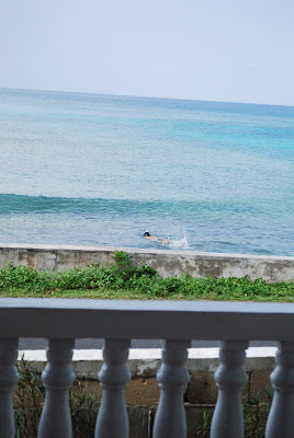
Watching Matt snorkel from our kitchen.


Our place is in Carrot Bay, which is on the North-West Side of the island. Of course, the reason I chose Carrot Bay is because Ginger Island is undeveloped, uninhabitable and buying an island is simply not in our price range. Carrot Bay has an 'old island' feel. It's not a touristy spot. It's a little fishing village with one church, a couple of hole in the wall bars/restaurants and amazing panoramic views. It's a 5 minute drive in every direction to amazing swimming beaches and it's on one of the only roads on the island that is actually flat and, believe it or not, has a name.


Stacy's new work desk.

When we wake up in the morning we can crack our windows, open the double doors and listen to the waves crash as we work through our $8.00 box of corn flakes.


It's quite hot here as of right now, so come 8:30pm you will probably find us strewn on the couches in our hybrid living-kitchen-room, watching The Wire (because Matt misses Baltimore desperately), zapping mosquitos with a battery operated electrified badminton racquet. If I had time, I would write a post strictly dedicated to my obsession with purging these blood suckers from my existence... but i'll save that for a rainy day.


Anyway, our search is over, we are settling in, and to my embarrassment, getting excited to hit up St. Thomas (which was recently called “The Detroit of the Islands” by a co-worker) for a K-mart run so that we can add a bit of color and perhaps get a small table so that we don't have to sit the desk top computer on our spare tire.

-Stace

Monday, October 12, 2009

Semi-dirigible on the high seas.

On Sunday, we rented a tiny dinghy for a day of island hopping. Our friends Tim and Paul handled the logistics while Clint, Michelle, Stacy and I tagged along and figured out a route for the day. The boat was rather tiny, and we were nervous due to our last experience crisscrossing Drake Channel in a much larger boat and getting soaked due to the waves.

Tim, Paul, Clint and Michelle

We headed for the southern coast of deserted Ginger Island for some snorkeling first. Upon arrival, a massive reef stopped our progress towards shore. We were in about 50ft of water with 200 yards of open ocean between us and the outer edge of the reef. I stuck my head over the side and noticed the deep blue color of the ocean fade into darkness around all sides and got nervous about snorkeling in such an isolated area. Some jellyfish persuaded every else and we decided to head to Cooper Island.

Checking the scene...

On the way to Cooper, our speeding dinghy kept flushing flying fish from the water in front of us. As we sped along at about 25 knots the fish erupted from the water and glided along, inches above the surface, easily keeping pace with our boat. It was absolutely awesome to see a fish leap out of the water, and fly through the air, with only it's tail flicking the water every once in a while to keep it going. They could fly for about 10 seconds before splashing back down, supposedly well away from whichever predator flushed it in the first place.

At Cooper, we saw a stingray searching for snacks in the sea grass and some incredible coral formations. We hopped back in the boat and headed toward Salt Island and the wreck of the Rhone. This is the legend of The Rhone according to wikipedia;

On the fateful day of the sinking, the captain of the Rhone, then Robert F. Wooley, was slightly worried by the dropping barometer and darkening clouds, but because it was October and hurricane season was thought to be over, he and the Conway stayed put in Great Harbour. The first half of the storm passed without much event or damage, but the ferocity of the storm worried the captains of the Conway and the Rhone, as their anchors had dragged and they worried that when the storm came back after the eye of the storm had passed over, they would be driven up onto the shore of Peter Island.

They decided to transfer the passengers from the Conway to the "unsinkable" Rhone; the Conway was then to head for Road Harbour and the Rhone would make for open sea. As was normal practice at the time, the passengers in the Rhone were tied into their beds to prevent them being injured in the stormy seas.

The Conway got away before the Rhone but was caught by the back end of the storm, and foundered off the south side of Tortola with the loss of all hands. But theRhone struggled to get free, as its anchor was caught fast. It was ordered to be cut loose, and lies in Great Harbour to this day, with its chain wrapped around the same coral head that trapped it a century and a half ago. By this stage time was critical, and captain Robert F. Wooley decided that it would be best to try to escape to the shelter of open sea by the easiest route, between Black Rock Point of Salt Island and Dead Chest Island. Between those two island lay Blonde Rock, an underwater reef which was normally a safe depth of 25 feet (7.6 m), but during hurricane swells, there was a risk that the Rhone might founder on that. The Captain took a conservative course, giving Blonde Rock (which cannot be seen from the surface) a wide berth.

However, just as the Rhone was passing Black Rock Point, less than 250 yards (230 m) from safety, the second half of the hurricane came around from the south. The winds shifted to the opposite direction and the Rhone was thrown directly into Black Rock Point. It is said that the initial lurch of the crash sent Captain Wooley overboard, never to be seen again. Local legend says that his teaspoon can still be seen lodged into the wreck itself. Whether or not it is his, a teaspoon is clearly visible entrenched in the wreck's coral. The ship split in two and cold sea water made contact with the red hot boilers which had been running at full steam, causing them to explode.

The ship sank swiftly, the bow section in eighty feet of water, the stern in thirty. Of the original 146 aboard, plus an unknown number of passengers transferred from the Conway only 23 people (all crew) survived the wreck

So, we tied ourselves to one of the mooring balls about a hundred yards from Black Rock Point, the same rocks that caused the sinking of the Rhone more than 140 years ago, and jumped off into the dark blue waters.

The history of the area sinks in as we prepare ourselves.

Tim performs some reconnaissance. Infamous Black Rock is on the right.

As we moved towards the rocks, wreckage became visible in the depths. We could see some beams of steel, some ribs of the hull and a massive propeller. Diving down close to the wreckage, you could see inside of smashed hull and more of the structure became visible. We made the dive to the bottom and scouted out the insides of the sunken ship. Some of us then down down and swam through a passageway in the wreckage, underneath a chunk of hull and twisted metal, and out the other side. Seeing this enormous, broken ship, remembering the history that transpired on this very spot back when she actually sank, and thinking of the hundreds of people who died in the waters we were swimming was one of the most profoundly awesome experiences for us in the BVI to date. Surfacing and looking around at the other empty mooring balls at this usually popular dive spot, we realized how lucky we were to have this place all to ourselves.

After that, we headed to The Bight on Normal Island, one of the most sheltered harbors in the BVI, to board a boat called The Willy T, and get some lunch. To board the Willy T, just moor your boat along side and climb up. They have a restaurant and a bar.


An appropriately-named boat for the day.

After that, we headed to the other side of Normal Island to a site called The Caves for more snorkeling. Here, we saw 4 species of angel fish that we had not spotted before, as well as an eel hidden in the coral.

The Caves loom like nostrils in the distance.

Returning to the boat, we headed to our last destination of the day: The Indians. These islands are so named because from Tortola, they appear as an indian headdress sticking out of the water. They are nothing more than exposed pillars a rock emerging from turquoise waters between Norman and Peter Island.

The Indians in perfect light.

Stace goin' for it.

This was, hands down, the best snorkeling we have experienced so far. The coral formations were huge, colorful and healthy. We saw a sea turtle, some fish never seen elsewhere by us, and Paul and Tim spotted a shark.

Stace in 40ft of water near the Indians.

Tim and Paul need to be picked up, or see a shark, or whatever this signal means.

Clint and Michelle return to the boat.

After spending a good hour exploring this incredible place, we hauled our tired selves back onto the boat, Stacy took the helm and steered us across the channel back to Road Town and Nanny Cay Marina.

Stace takes us in. The Indians are the tiny rocks over her left shoulder.

I had to convince the 4 other boat mates to let her drive. Luckily, everyone was still in the water and didn't see this.